 |
|
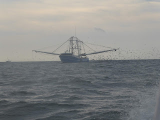
A photo from 11/26 on the ocean after leaving the St. John’s River. The birds are waiting for the scraps as the
trawler goes through the net.
|
 |
|
Sailing with Dale and Roni on Dale’s Sage 17 on
the St. Lucie River in Stuart, FL.
|
 |
|
This picture is taken in Manatee Pocket (after we left
Stuart) where our good friend Arnaud lives.
We stopped to visit with Arnaud before heading to Peck Lake for the
night.
|
12/7/18
We made it to Georgetown!
South winds going east across the gulf stream into Bahamian waters,
across the banks to the Northwest Passage Light, down the Tongue of the Ocean,
across the banks to the Exuma Sound down to Georgetown. It was a smooth passage which means no
stories to tell; about 54 hours total!
Story telling happens when something goes wrong. Nothing went wrong!
Ah, passagemaking, where the most exciting thing to happen,
sometimes, is studying the sun or moon going down or coming up while on watch.
Our last night out Venus was already up lighting the sky around 4 am when the
moonglow started to appear under Venus. First just a luminescence in the
eastern horizon that brightened with the moon’s rise. I watched the sliver of moon come up over
Farmer’s Cay and through a hole in the cloud I could see the moon’s unlit
surface pocked with craters as well as the sliver of moon at the base forming a
cup. No wind. Flat water.
Star’s reflections dancing on the water surface. And it was warm!
Oh, one story to tell.
When leaving Stuart our wind meter display only worked to show wind direction. Not speed.
This had happened once before when we started the engine with the meter
already on. I realized that it had
suffered a stroke. At first – no reading
for speed at all. Then random numbers
started to appear in the display screen the next day. Slowly, the wind meter learned what it once
knew – how to understand the electrical impulses it receives from the cuppy-spinny
thing (the technical name for the anemometer) at the top of the mast to tell us
something useful. The next day we had
readings on the port tack only. Arriving
in Georgetown it is back on the job and we can tell you the wind has been
honking since arrival with gusts up to 35 knots the other night.
Once in Elizabeth Harbor, Georgetown, Exumas we were surprised
at how few boats were anchored throughout the harbor. Maybe 30 boats total. We’re used to seeing at least 100 and during
regatta time up to 400. We’re
early! Clearing in at customs and then
immigration involved launching the dingy, tying to the dinghy dock behind Exuma
Market, and walking to each location to fill out all the forms, pay the $300,
and chat with the officials. If you
checked our SPOT you’ll see that we anchored first near town and then after
clearing in we anchored at Monument Beach across the harbor. We were the only boat anchored here! Dinner and then to bed early after being on
our watch schedule for the last couple days.
The next afternoon we decided to take the dinghy back across
the harbor to town. My sister and her
family gave us an old iphone they weren’t using anymore. We visited the nice lady, Keva, at Batelco,
the telephone company here in the Bahamas, and signed up for a data only plan
for now and have spent the rest of the day trying to figure out the ins and
outs of using a smartphone, using it as a personal hotspot, and typing out some
news to send friends and family. The sun
is shining brightly. It has been in the
80s since our arrival. Finally warm!
 |
|
Jerry takes a sunset picture as we motor sail across the
banks toward the Exuma Sound with little to no wind.
|
 |
|
Here we are anchored off Monument Beach by ourselves. In front of us is Stocking Island.
|
 |
|
Here’s last year’s
view of the same anchorage where we are now. Look at all the boats!
|
 |
|
Another view of our anchorage at Monument Beach now. (There is a monument on the top of the hill
at left.)
|


